The feature was designed by engineers from San Francisco, New York, and Zurich, according to an article written by Avichal Garg, product manager of the transit team. All of the engineers use public transportation regularly. They devoted 20 percent of their time per week to building this new feature on Google.
There are only a few simple steps you need to take to get to the public transit map:
1) Go to Google.com
2) Click on “Maps”
3) Click on “Get Directions”
4) Type in a “start address” and an “end address”
5) Click “Get Directions”
6) Then, under “Search Results” there should be on option where you can click “Take
Public Transit”.
7) Once you select the option a new Google map will appear with new directions.
I think it is such a great feature to have on a website, especially if you are moving to a new city and you have no way of getting around but by public transportation.
When you get the directions, Google lists how much time it will take you to walk to the bus stop or train station; it tells you which bus you will need to board and the time that it departs and arrives; and it states how much time you will need to walk to reach your final destination.
Google has not created transit maps for every city and state, because the feature is so new. However, you can plan trips in seven states and one other country other than the U.S. – Japan.
California
- Bay Area (BART)
- Burbank (Burbank Bus)
- Humboldt County (Various)
- Orange County (OCTA)
- San Diego (MTS)
- Thousand Oaks (Thousand Oaks Transit)
- Bay Area (VTA)
Florida
- Tampa (HART)
Hawaii
- Honolulu (TheBus)
Minnesota
- Duluth (Duluth Transit)
Nevada
- Las Vegas (Monorail)
- Reno (RTC RIDE)
Oregon
- Eugene (Lane Transit District)
- Portland (TriMet)
Pennsylvania
- Pittsburgh (Port Authority)
Texas
- Austin (Capital Metro)
- Dallas (DART)
Virginia
- Hampton Roads (HRT)
Washington
- Seattle (King County Metro)
Japan
- Japan (All regional and national rail networks, domestic airlines and ferries)
By using this new feature you will not only save on gas money, but you will reduce auto emissions which cause the nasty greenhouse effect that is very bad for our environment.
Public transportation saves approximately 1.5 million tons of carbon dioxide annually and 1.4 billion gallons of gasoline annually.
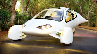
Apart from the new Google feature, I also discovered one of the most beautiful cars I have ever seen in my life and I just had to put it up here...
The photo below is courtesy of a flickr member and it is an Aptera three-wheeled electric car. The car gets 230 miles per gallon.

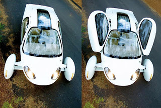
Here is a picture of the car from the top:

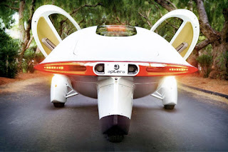
Here is the back view:

For more information on the Aptera you can check out the Aptera website


No comments:
Post a Comment